Machine Control · Earthworks · Digital Construction · Self-Delivery
Trimble Machine Control: How GPS Machine Control Improves Earthworks Productivity and Accuracy
Bulk earthworks set the programme for almost every mission-critical project. If the platform is late, or built to the wrong level, everything that follows — foundations, drainage, high-voltage civils — inherits the delay. Trimble machine control is the discipline that keeps earthworks on line and on level by putting the 3D design model directly into the machine cab.
Maveric runs GPS machine control as a standard part of its self-delivery model. Because we operate our own crews and our own plant rather than subcontracting the work, the design data, the dozers and excavators, and the survey record stay under one chain of control. This article explains how machine control earthworks actually work, where the productivity and accuracy gains come from, and how the system connects to survey and BIM.
What GPS machine control is
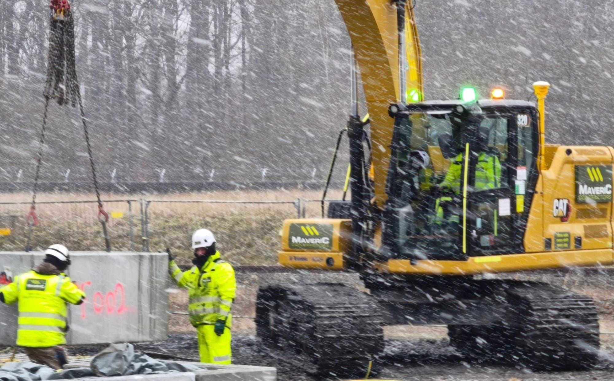
GPS machine control is a guidance system that compares a machine's real-time position against a 3D design surface and tells the operator — or the hydraulics — exactly where the blade or bucket needs to be. A GNSS receiver fixes the machine's position, sensors measure the attitude of the boom, dipper and bucket, and an in-cab display shows cut and fill relative to design, typically to within a few centimetres in plan and level.
Two modes are common. In guidance, or indicate, mode the operator sees how far they are above or below target and works to it manually. In automatics, the system controls blade or bucket elevation directly, holding grade while the operator concentrates on speed and direction. Trimble is one of the established systems in this field; the underlying principles are common across the machine-control platforms used on civil sites.
How Trimble machine control works on site
The workflow starts in the office, not the cab. A surveyed 3D model — the design surface, with levels, falls and tie-ins — is prepared and loaded to the machine. A site correction source, typically a base station or a network RTK service, lifts positioning from metre-level to centimetre-level accuracy. From there the operator works directly to the model.
The sequence is straightforward and repeatable:
- Build or import the 3D design surface from the engineer's model
- Establish a base station or connect to an RTK correction network
- Calibrate the machine and verify against known control points
- Load the surface to the in-cab display and confirm cut and fill
- Excavate or grade to design, checking conformance as work proceeds
Setting-out without pegs
Traditional earthworks depend on a grid of pegs, profiles and batter rails, set out by an engineer and re-set every time plant disturbs them. Machine control removes most of that. The design exists as data in the cab, so the operator can dig a trench, trim a batter or form a platform without waiting on physical setting-out, and without the safety exposure of people working close to live plant to check levels.
Accuracy depends on the application. Bulk and general earthworks are held to centimetre-class GNSS tolerances across large areas. For close-tolerance work — final-trim grading of platforms and sub-formation — augmenting the machine with a total station or laser reference tightens vertical control to the few-millimetre band the surface demands. That matters on sites where a flat, accurate platform is a precondition for everything above it: a data-centre slab, a substation compound or a battery-storage array. The same model drives both bulk movement and final trim, so cut and finish are governed by one source of truth.
Where the productivity and accuracy gains come from
Machine control productivity is not really about making one machine faster. It comes from removing the stop-start cycle of conventional earthworks — dig, wait for survey, check, adjust, re-survey — and from getting the levels right the first time.
The accuracy gains translate directly into less rework and less over-dig. Over-dig is expensive twice: you pay to excavate material you did not need to move, then pay again to import, place and compact fill to bring the level back up. Working to a model keeps cut and fill close to design, which reduces wasted excavation, reduces imported fill, and cuts the haulage and plant hours that go with both.
- Less rework — surfaces are built to design the first time
- Less over-dig and over-fill, with the material and haulage savings that follow
- Fewer survey hold-points interrupting production
- Reduced exposure for people working on foot near operating plant
- A consistent finish across large platforms and long trenches
Closing the loop with payload weighing
Accuracy on the ground is only half the picture; the other half is what leaves site on a truck. On-board payload weighing, such as Caterpillar's Cat Payload system, measures material in the bucket or body as it is loaded, so an operator can fill a truck close to its legal limit without guessing, repeated weighbridge trips or overloading.
Used alongside machine control, payload weighing closes the loop on bulk earthworks. It supports accurate muck-away records and balanced haulage, helps avoid the safety and compliance problems of overloaded vehicles, and feeds real volumes back into the project's earthworks balance rather than relying on estimates. The result is a cleaner, more defensible picture of what was cut, moved and placed.
Integration with survey and BIM
Machine control is most valuable when it is not an island. The model in the cab should be the same model the engineers designed to, and the as-built data the machines generate should flow back into the project record. At Maveric this sits within a wider field-technology stack — GNSS and machine control, ground-penetrating radar and vacuum excavation for safe digging around live services, and drone survey with photogrammetry feeding the BIM model.
That integration gives a continuous digital thread from design to handover. Survey defines the ground; the model drives the plant; as-built and volume data confirm what was built; and the project closes out with a full digital record rather than a folder of paper levels. For clients and main contractors on mission-critical infrastructure, that traceability is as valuable as the speed on site, and it is reinforced by Maveric's management systems, aligned to ISO 9001 for quality, ISO 14001 for environment and ISO 45001 for safety.
Frequently asked questions
What is the difference between GPS machine control and Trimble machine control?
GPS machine control is the general technology — guiding plant against a 3D design model using satellite positioning. Trimble is one of the established machine-control systems that delivers it, alongside other platforms used on civil sites.
How accurate is GPS machine control for earthworks?
With a base station or an RTK correction network, machine control typically achieves centimetre-level accuracy in plan and level across the working area. Final-trim and grading applications, augmented by a total station or laser reference, hold tighter vertical tolerances for close-tolerance surfaces.
Does machine control remove the need for traditional setting-out?
It removes most of the pegs, profiles and batter rails on which conventional earthworks rely, because the design sits as data in the cab. Survey control points are still established and checked to calibrate and verify the system.
How does machine control reduce rework and over-dig?
By showing cut and fill against design in real time, the operator builds the surface to level the first time. That keeps excavation close to design, reducing over-dig, the imported fill needed to correct it, and the associated haulage and plant hours.
What does on-board payload weighing add to machine control?
It weighs material as it is loaded into a truck or bucket so the vehicle can be filled close to its legal limit without guesswork or repeated weighbridge trips. It supports accurate haulage records, helps prevent overloading, and feeds real volumes back into the earthworks balance.
How does machine control connect to survey and BIM?
The model loaded to the plant is the same design surface the engineers produced, and the as-built and volume data flow back into the project record. Combined with drone photogrammetry and survey, this creates a continuous digital thread from design to a full digital handover.